KANSAS CITY, Mo. – A powerful line of severe thunderstorms tore through the Kansas City metropolitan area on Tuesday afternoon, leaving a trail of damage, overturned semi-trucks, flooded roadways, and widespread power outages. The storms prompted multiple tornado warnings, flash flood alerts, and hazardous driving conditions across the region.
Storm Causes Major Traffic Disruptions
The high winds associated with the storms were strong enough to blow over two semi-trucks on major highways:
- I-435 Southbound near Raytown Road and Eastwood Trafficway (Jackson County, MO)
- I-635 Southbound at Parallel Parkway (Wyandotte County, KS)
Both incidents blocked multiple lanes, causing significant delays. Additionally, a two-vehicle crash on I-435 Southbound past I-70 further compounded traffic issues, shutting down the two left lanes.
The Kansas Department of Transportation (KDOT) also reported a full closure of K-5 in both directions between Eisenhower Road and E. Mary Street near Lansing, Kansas, due to storm-related hazards.
Power Outages and Emergency Responses
Evergy reported thousands of customers without power across the Kansas City metro as the storms downed power lines and tree limbs. In Raytown, a Kansas City Fire Department ambulance was struck by a falling tree or large limb and had to be towed from the scene.
Emergency crews also responded to an injury crash involving a semi-truck on I-635 near Parallel Parkway in Wyandotte County.
Tornado Warnings Issued and Later Canceled
The National Weather Service (NWS) issued multiple tornado warnings throughout the afternoon, though all were canceled by 3:30 p.m. Some of the affected areas included:
- Johnson, Cass, and Jackson Counties (MO)
- Ray and Lafayette Counties (MO)
- Miami and Johnson Counties (KS)
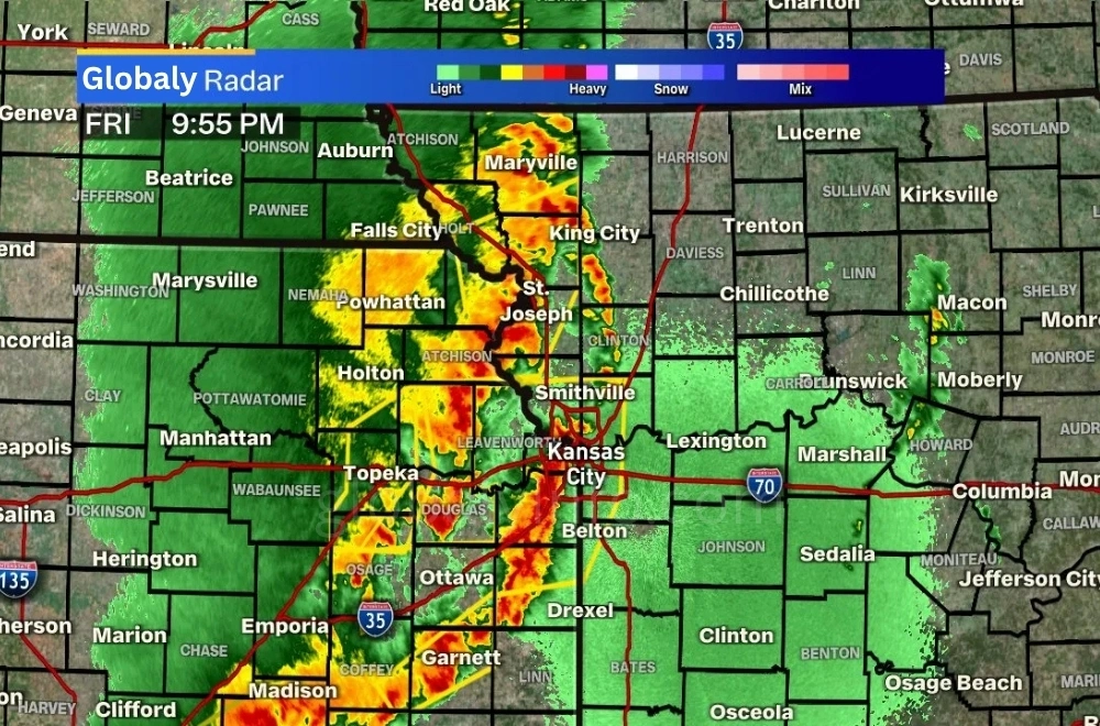
While no confirmed tornadoes were reported, the storms produced damaging straight-line winds, hail, and intense rainfall.
Flash Flooding Becomes a Growing Concern
A Flash Flood Warning remained in effect for parts of the metro until 7 p.m., with additional heavy rain exacerbating flooding risks. Drivers encountered high water on Interstate 35 and other low-lying roadways.
The NWS warned that 1 to 3 inches of rain had already fallen in some areas, with localized amounts reaching up to 4 inches in central Missouri. This led to:
- Street flooding
- Rising creeks and streams
- Potential river flooding in the coming days
Severe Weather Timeline and Live Updates
Key Storm Updates (Tuesday, May 29, 2025)
- 3:32 p.m. – KCFD ambulance struck by a falling tree in Raytown.
- 3:28 p.m. – New Severe Thunderstorm Warning issued for multiple Missouri counties until 4:15 p.m.
- 3:21 p.m. – Tornado Warning for Ray and Lafayette Counties canceled.
- 3:02 p.m. – Injury crash involving semi-truck on I-635 in Wyandotte County.
- 2:55 p.m. – New TORNADO WARNING issued for Ray, Lafayette, Clay, and Jackson Counties (MO).
- 2:17 p.m. – Flash Flood Warning expanded to include Wyandotte, Johnson, Leavenworth (KS), and Platte, Cass, Clay, Jackson (MO) until 7 p.m.
- 2:08 p.m. – Tornado Warning issued for Johnson County (KS) and Cass/Jackson (MO).
- 1:46 p.m. – First Tornado Warning of the day issued for Miami and Johnson Counties (KS).
- 1:39 p.m. – Tornado Watch issued for multiple counties in Kansas and Missouri.
- 1:12 p.m. – Initial Flash Flood Warning issued for Atchison, Leavenworth, Wyandotte (KS), and Platte (MO).
First Alert Weather Day: Ongoing Risks
Tuesday was designated a First Alert Weather Day due to the potential for damaging winds, hail, and isolated tornadoes. While the morning storms reduced some instability, the afternoon wave (2 p.m. – 7 p.m.) still posed risks, including:
- Damaging wind gusts (60+ mph)
- Flash flooding
- Large hail
- Brief tornadoes (especially south of I-70)
Safety Precautions and Travel Advisory
Authorities urged residents to:
✔ Avoid unnecessary travel due to flooded roads and debris.
✔ Stay weather-aware for additional warnings.
✔ Report downed power lines to Evergy or local utilities.
✔ Monitor rivers and creeks for rapid water rises.
Conclusion
The severe thunderstorms on May 29, 2025, caused significant disruptions across the Kansas City metro, with overturned trucks, power outages, and flash flooding. While the tornado threat has diminished, flooding remains a concern overnight. Residents should stay updated via FOX4 Weather Alerts and avoid driving through high water.